Urban Data Science
- Image
- Image
- Image
- Image
- Image
- Image
We integrate sensing, modeling and simulation, visualization, control and optimization, and - more broadly - artificial intelligence to enable planning, design and policy-making responses to critical urgent challenges related to the climate crisis, digital citizenship, healthy lifestyles, urban innovation and building just and sustainable cities.
Overview
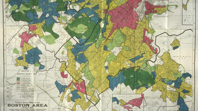
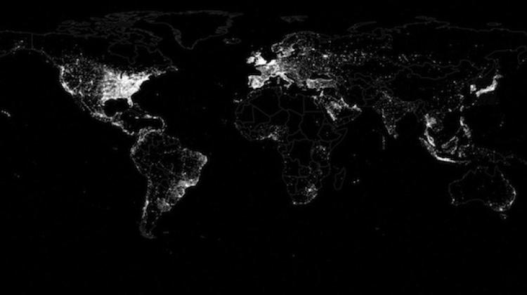
As the complexity of global urban challenges continually increases, so do the range and powers of computational tools and techniques planners have at their fingertips. Planners today require an ability to make sense from large amounts of data and a facility with analysis, visualization, sensing, data ethics and reciprocity, and the integration of artificial intelligence into planning and policy-making contexts in a democratic and ethical manner. DUSP has long been at the forefront of related research and teaching and has developed new technologies and tools with community partners to model, envision, and communicate information about the city. Our approach involves novel application of computational and/or data science methods to critical priority areas, such as decarbonization, urban and regional adaptation and resilience, environmental justice, energy and natural resource systems, and participatory methods. We aim to co-create innovative computational approaches to meet the needs of cities and communities, in interdisciplinary, and community-serving ways.
People
Rounaq Basu
 Postdoctoral Associate
Eran Ben-Joseph
 Class of 1922 Professor of Landscape Architecture and Urban Planning
Gabriel Bonnamy
 MCP Student
Cong Cong
 Lecturer of Urban Science and Planning
Karilyn Crockett
 Class of 1958 Career Development Professor of Urban History, Public Policy & Planning
Catherine D'Ignazio
 Associate Professor of Urban Science and Planning
Fabio Duarte
 Associate Director (Senseable City Lab) + Lecturer of Technology and Urban Planning
Yichun Fan
 Doctoral Candidate
Pedro Ferraz de Abreu
 Visiting Scholar
Joseph Ferreira
 Professor, Post-Tenure
Umberto Fugiglando
 Head of Research Strategy & Partnerships, MIT Sensible City Lab
Fadi G. Haddad
 MCP Student
Yutian He
 MCP & SM EECS Candidate
Kevin Hsu
 GE Vernova Fellow & PhD Candidate
David Hsu
 Associate Professor of Urban and Environmental Planning
Songhua Hu
 Postdoc, SCL
Xinyi Huang
 MCP & MST Student
Eric Robsky Huntley, GISP
Lecturer in Urban Science and PlanningKee Moon Jang
 Postdoctoral Associate
Cameron Kleiman
 Undergraduate
Zhaoxiang Li
 PhD Student
Liu Liu
 Doctoral Candidate
Yifeng Liu
 Master Student @ DUSP & EECS
Chang Liu
 Postdoc, Senseable City Lab
Sebastian Olascoaga
Lecturer in Urban EconomicsRhoda Osei-Nkwantabisa
 MCP Student
Lidia Cano Pecharroman
 Doctoral Candidate
Andres Sevtsuk
 Charles and Ann Spaulding Associate Professor of Urban Science and Planning, Head of City Design and Development Program Group
ChenAn Shen
 MCP&MST Student
Wonyoung So
 Ph.D. '25
Anne Whiston Spirn
 Professor of Landscape Architecture and Planning
Rongxiang Su
 Postdoc, SCL
Mingyang Sun
 MCP Student
Lawrence Susskind
 Ford Professor of Urban and Environmental Planning
Freya Tan
 MCP & MS EECS Student
Diego Temkin
 SB Candidate
Claudia Tomateo
 Doctoral Student
Sarah Williams
 Norman B. (1938) and Muriel Leventhal Prof of Architecture and Planning
Hanyong Xu
 PhD Candidate
Niaz Mahmud Zafri
 Doctoral Student
Chris Zegras
 Professor of Mobility and Urban Planning
Jinhua Zhao
 Head and Professor of Cities and Transportation
Siqi Zheng
 Professor of Urban and Real Estate Sustainability
Bachelor of Urban Science and Planning with Computer Science
The 11-6 degree (Bachelor of Urban Science and Planning with Computer Science) aims to help MIT undergraduates use their computer science skills to make positive social impacts. For the predominantly technically-minded undergraduates at MIT, working within real urban contexts and environments will introduce them to:
- Fundamental and socially-relevant questions of equity, fairness, diversity;
- Specific applications of computer science skills (e.g. statistics, data science, geospatial analysis, and visualization) to urban-related questions;
- Diverse contexts in which technology is tested and used.