Favelas 4D

Nearly one billion people live in informal settlements worldwide. In Brazil, these settlements are known as favelas, and they are characterized by a dense and complex urban environment. A multilayered architecture emerges when residents build their own homes and businesses without a master plan.

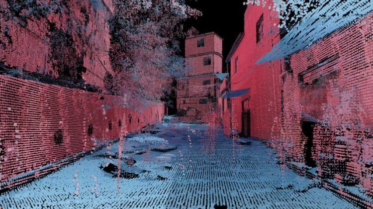
Using 3D laser scanning technology, the Senseable City Lab, in collaboration with BRTech 3D, is conducting a comprehensive morphometric analysis of Rocinha, the largest favela in Rio de Janeiro and home to about 100,000 people. The scientific analysis quantitatively captures the ingenious construction practices and dire infrastructural needs of the favela, revealing the urban logic of Rocinha with unprecedented precision. Favelas 4D illuminates Rocinha’s shape and organization in a new and comprehensive way, representing an impactful step towards the inclusion of the informal city in our global and digital urban future.

Favelas 4D: Scalable methods for morphology analysis of informal settlements using terrestrial laser scanning data

One billion people live in informal settlements worldwide. The complex and multilayered spaces that characterize this unplanned form of urbanization pose a challenge to traditional approaches to mapping and morphological analysis. This study proposes a methodology to study the morphological properties of informal settlements based on terrestrial LiDAR (Light Detection and Ranging) data collected in Rocinha, the largest favela in Rio de Janeiro, Brazil. To measure the morphology of the informal settlement, we propose a series of five metrics related to the geometric characteristics of streets: street width, street elevation, facade heterogeneity, facade density, and street canyon. Our analysis operates at two resolutions, including a global analysis focused on comparing different favela streets to one another and a local analysis unpacking the variation of morphological metrics within streets. We show that our methodology reveals meaningful differences and commonalities in terms of the global morphological characteristics across streets and their local variations, which align with the historical evidence of the favela’s development. Finally, we create morphological maps at high spatial resolution from LiDAR data to inform urban planning assessments of concerns related to crowding, structural safety, air quality, and accessibility in the favela. The methods for this study are automated and can be easily scaled to analyze entire informal settlements, leveraging the increasing availability of inexpensive LiDAR scanners on portable devices such as cellphones.

https://doi.org/10.1177/23998083221080174