
Making Informal Urban Spaces Visible
By the year 2050, the United Nations predicts that more than two-thirds of the world population will live in urban environments. For many envisioning this city centric future places new urban residents in master planned developments, replete with supporting infrastructure and amenities. Yet, a significant proportion of the millions of people who migrate to and within the world’s cities every year add their number to the nearly one billion residents of informal settlements and slums around the world.
In Brazil, these settlements are known as favelas, and they continue to grow in the periphery of big cities like Rio de Janeiro. Favelas dense, multilayered forms contrast starkly with the government-administered neighborhoods next door and their informality and form provide a unique challenge for urban planners seeking to understand them better. Favelas 4D, a project at MIT’s Senseable City Lab (SCL), analyzes how and why these environments take on such intricate shapes, with the hope that through the mapping process that favelas and their residents might obtain more urban rights.
"Despite their challenging circumstances, favela residents have developed ingenious and responsive ways to build their own urban systems,” said Carlo Ratti, SCL’s director. “This bottom-up planning process and the complex architectural forms it produces can challenge the standard way of designing cities."
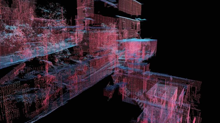
To explore the favela’s architecture with extreme precision, SCL researchers conducted their analysis using a LiDAR scan of the Rocinha settlement in Rio de Janeiro. LiDAR, which stands for “Light Detection and Ranging,” is a laser scanning technology that maps minuscule points to positions in space in order to create a “point cloud” that describes the 3D geometry of its subject.
Taken from street level, LiDAR provides an incredibly detailed representation of Rocinha’s urban environment, offering an unprecedented level of insight into the favela’s urban and architectural logic.
It is generally understood that informal settlements follow their own architectural protocols governed by common sense and community guidelines. However, studies of slum expansion and informal settlement architecture tend to rely on remote sensing data, like satellite images, that give only a distant bird’s eye view of their shape and organization. Working in collaboration with local urban planners, policy makers, and community leaders, Favelas 4D frames viewers perspective to the street-level and levels of detail that would be difficult to obtain via traditional methods.
The project traces patterns in the favela’s urban form, using spatial metrics like street width and building height to produce detailed maps that can indicate hotspots of common issues in informal settlements, such as crowding and landslide risk. This quantitative spatial information will most immediately benefit Brazilian government agencies hoping to anticipate the spatial and infrastructural needs of the growing favelas, but its applicability extends beyond the city of Rio.
"The findings could also be used to develop planning strategies that make the formal city more inclusive to informal settlements, or to spark research into alternative ways of building that make urban environments more accommodating and affordable to their growing populations," said Washington Fajardo, City Planning Commissioner for Rio de Janeiro, former Loeb Fellow, and collaborator on the project.
Favelas 4D offers a new direction of scalable urban analysis for informal settlements. Its analytical methods will enable the interpretation of Rocinha’s entire built environment when the whole favela is scanned at street level, an outstanding feat that will foster insights relevant to both the improvement of favela conditions and the field of city-building overall.
The MIT team includes, Carlo Ratti, Fábio Duarte, Arianna Salazar Miranda, Guangyu Du, and Claire Gorman with collaboration from Washington Fajardo.